12. Tsunami Warning Centre
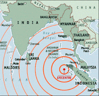
The 2004 Indian Ocean earthquake was an undersea earthquake that occurred on 26 December 2004, with an epicentre off the west coast of Sumatra, Indonesia. The earthquake triggered a series of devastating tsunamis along the coasts of most landmasses bordering the Indian Ocean, killing large numbers of people in Indonesia, Sri Lanka, India, and Thailand. Initial estimates had put the worldwide death toll at over 275,000. The plight of the many affected people and countries prompted a widespread humanitarian response. In all, the worldwide community donated more than US $ 7 billion in humanitarian aid to those affected by the earthquake. Now comes some hope...
Leibniz University in Hannover is undertaking a 1.2-million euro (RM5.6 million) project to develop a tsumani early warning system for the Indian Ocean based on detailed flooding and evacuation simulators for the city of Padang in West Sumatra, Indonesia.
A team led by Professor Torsten Schlurmann has been working closely with leading scientists in this particular field from the entire country as well as their Indonesian counterparts on the project, which is sponsored by the German Government.
Padang which has a population of one million, is the third largest city in Sumatra and because of its direct coastal location at sea level, Padang is considered to be at high-risk for tsunamis in the earthquake prone region.
Along the west coast of Sumatra, a tsunami can engulf the coastal cities in some 18 to 20 minutes, according to scientists at Leibniz University.
By means of scientific evaluations of detailed flooding dynamics and optimum early warning and evacuation mechanisms in Padang, the project's `last mile evacuation' would make a supplementary contribution to the big project of setting up a tsunami early-warning system in the Indian Ocean, headed by the Geo-Research Center of Potsdam.
Under the "last mile evacuation" project, the scientists of an interdisciplinary research team will rely on satellite-based observation data of the earth, simulators of the over-flooding dynamics and the probable evacuation behaviour of the people.
The data would provide a "visualized artificial world" of Padang city. Additionally, an area of some 500 sq. km. would be covered by a part of the project with a stereo camera system, which would provide very precise view of the altitude of the land and also individual buildings.
The project is aimed to make an overall and effective determination of the tsunami early warning system in Padang city. This goal is based on components of the tsunami detection system in deep water as well as the processing of data and the setting off of the alarm system in the central Indonesia crisis and information centre, thus creating what the researchers claim would be a `locally-oriented crisis and information centre'.
Since the devastating tsunami of December 26, 2004, scientists of Indonesian and German research institutes have been working on setting up a dependable deep-water early warning system with the deployment of GPS buoys and ocean floor pressure sensors, which should be put into operation at the end of the coming year off the coast of Indonesia.
The "last mile evacuation" project includes local authorities and NGOs in Padang as well as Indonesian research institutions. Over and above, the project will involve cooperation with the German Society for Technical Cooperation in the region.
In Germany, there are other bodies involved such as the Institute for Environmental and Human Safety of the University of the United Nations, the University of Wuerzburg, the Technical University of Berlin, the German Institute for Aerospace as well the small and medium-sized companies - Report by Manik Mehta, BERNAMA.


